Relocation to Restoration Part 2: The TAP Visit Cherokee Forest
This blog is reposted from Cherokee Concerned Citizens

Meet & Greet Dinner: TAP members and Cherokee Forest residents. NOTE: Unless otherwise noted the photos in this blog are courtesy of TAP members who gave explicit permission to share for this story.
Site Visit
Members of the Relocation to Restoration (R2R) Project Technical Advisory Panel (TAP) traveled to Pascagoula to gain firsthand insight into the neighborhood’s conditions and contribute their expertise toward developing a strong relocation and restoration plan.
The visit began with an evening of introductions and storytelling, setting the tone for the day ahead. The following morning, Buy-In Staff, CCC, and the TAP members met at Barbara’s house for a walking tour of the Cherokee Forest neighborhood, followed by a “toxic tour” of the Bayou Casotte Industrial Parkway.
From there, the group traveled to Kreole Primary Elementary School and Saint Joseph’s Catholic Church in Moss Point, MS, where David Perkes, Executive Director of the Gulf Coast Community Design Studio and TAP member, led a tour of two ongoing green stormwater infrastructure projects that use nature-based solutions to manage flooding. After lunch, we returned to where we started the night before, Ingalls Avenue Baptist Church, to reflect on the day and identify what's next.
A Neighborhood in Transition
As TAP members walked the streets of Cherokee Forest, the story of a neighborhood already in transition began to emerge. There were once over 200 homes owned by occupants. Today, just over half of the households in the neighborhood are homeowners. About 30% of the neighborhood is vacant.
In many areas, entire streets have emptied out. Apache Street, for instance, now has only one home remaining. All of the thirteen homes experienced major damage during Hurricane Katrina. Every one of them also had at least one person diagnosed with cancer. Their homes stood just 150 feet from the Bayou Casotte Industrial Road and two shipbuilding operations, now owned by Bollinger.
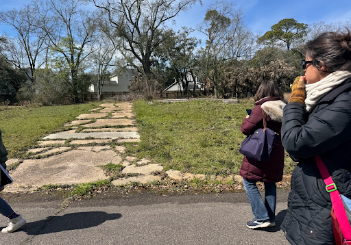
Some lots have remnants of concrete foundations or driveways; others are now indistinguishable from the surrounding overgrowth. On Navajo Avenue, a cul-de-sac near the creek and industrial sites, the landscape is dotted with empty lots. The visible abandonment—the slabs, cracked driveways, and overgrown lots—sends a message.
“Unaddressed blight makes residents feel like the city has given up on their neighborhood. But restoration and re-naturalization offer another path. Not only could this project improve water quality and reduce flood risk, but it could also reverse some of the emotional and psychological toll that abandonment brings.”


The area is highly flood-prone. A tidal creek cuts through the neighborhood, swelling during storms and heavy rains, often draining into Chicot Bayou near Beach Boulevard and Martin Street. The creek also separates Cherokee Forest and Delmas (the neighborhood located directly behind Cherokee). Cherokee Forest homes located along the creek have the highest incidences of flooding.
In recent years, the City has attempted to address drainage issues—particularly around Sea Cove Street—with curbs, gutters, inlets, and new paving. Erosion control efforts, such as placing rocks along the creek bank, appear to be failing. The cost of maintaining this infrastructure in a neighborhood that continues to depopulate raises tough questions.

Cherokee Forest resident, Mike Devine showing TAP members the tidal creek behind his home.

Tidal Creek running along the west side of Cherokee Forest neighborhood

Tidal creek cuts across Cherokee St. on the east side of the neighborhood.
Every home in the neighborhood suffered at least some damage during Hurricane Katrina. Many homes were completely destroyed. While most chose to rebuild, many others opted not to do so, leaving behind several vacant lots like the ones pictured.
As David Perkes noted during the neighborhood tour, when another major storm hits the area, many residents may be put in a tough position. According to federal rebuilding rules, if a home is damaged beyond 50% of its market value, the homeowner is required to elevate and bring it up to the current building code.
Elevating homes may protect residents from water, but it could increase their exposure to industrial air pollution. Higher homes are more likely to catch prevailing winds carrying emissions from nearby industries. In many ways, these solutions feel like a tradeoff rather than real progress. The photographs below show just how close the shipyard is to the neighborhood.


Toxic Tour
While one group was walking the neighborhood, the other was given a Toxic Tour of the Bayou Casotte Industrial Parkway. While driving down Bayou Casotte Industrial Parkway, the TAP witnessed both Chevron and BP Enterprise flaring.
The photograph below shows a smoking flare from the Chevron Refinery. Without further research we can’t say for sure what is being released, but we know a smoking flare for longer than 5 minutes is illegal. The smoking flare was visible throughout both tours lasting more than 45 minutes.
The photograph below is of BP Enterprise. Two of their smokestacks are visible in the picture. Residents report the facility flaring almost every day. What is more common to see at this facility (and difficult to capture in a photo) than a smoking flare is a clear vaporous haze coming from the smoke stack.

According to one EPA official, this means that the facility is releasing a significant amount of volatile organic compounds (VOC). The compounds include many known carcinogens, like benzene. Flaring is used to reduce VOC emissions through combustion. When done properly, 97% of VOCs are expected to burn off. A smoking flare, a very large flare, or a barely invisible flare is a sign flaring is not being done properly and are all permit violations.
Over the years, advocates have pressured the EPA to impose more stringent rules on flaring largely due to the difficulty in doing it properly and the ease at which facilities can get away with flaring continuously. Since 2016, coal refineries can only flare (even proper flaring) four times a year. The same rule does not apply to gas processing plants. Both BP Enterprise and Chevron have a flare recovery system that is supposed to prevent and/or reduce flaring.
In addition to the shipbuilding, oil, and gas facilities already mentioned, the Cherokee Forest subdivision sits across the street from the Port of Pascagoula, the former First Chemical and Mississippi Phosphates sites (both in remediation), Oleo-X, and Enviva Biomass export terminal. Also nearby are Gulf LNG export terminal, Destin Pipeline, and two very large radioactive phosphogympsum stacks (now a Superfund site – see photos below).

Partial view of the first phosphogympsum stack (currently closed and capped). Many Pascagoula residents see it as a hill rather than the environmental hazard it is.

Aerial photo of MS Phosphates Gypsum stack taken by South Wings 2020
Living too close to too many polluting facilities carries great risk from the almost daily exposure to toxic chemicals, acute exposure from accidents, such as the 2016 explosion at BP Enterprise, and major storms and hurricanes, such the 2015 incident at Chevron that happened after heavy rainfall and resulted in the release of about 4 million gallons of pentane-hexane hydrocarbon material stored on site.

BP explosion 2016. Photo taken by Cherokee resident.
Buffers between industry and residential communities are necessary to keep people and families safe. Relocating willing residents of Cherokee Forest and converting the land into a forested buffer can help not protect not only the fenceline residents that move but also nearby neighborhoods, such as Delmas. Check out Part 3 of this series to learn what a difference a forested buffer could make.